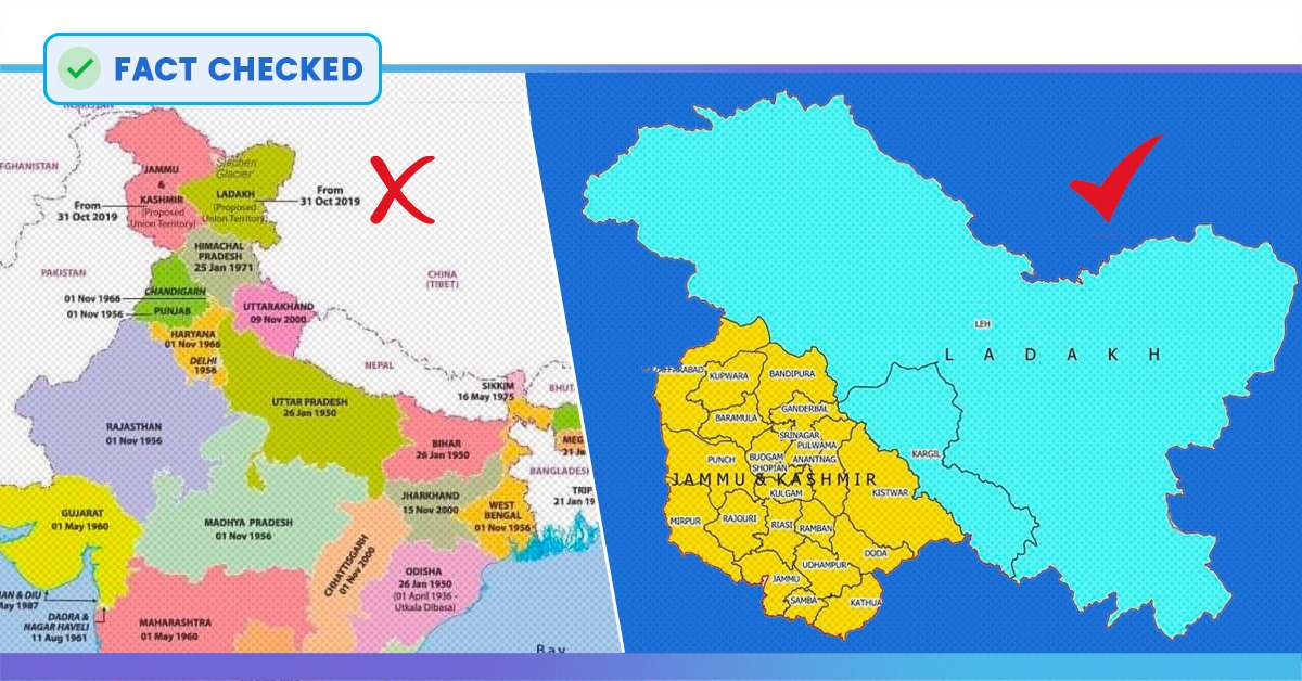
After the abrogation of Article 370 on August 5th, the President of the country ordered a new map reflecting the bifurcation of the state of Jammu and Kashmir. The latest version of Indian map was released on 31st October by the Survey General of India. But, since then, a parallel map of India showing a differently bifurcated J&K into union territories of Jammu & Kashmir and Ladakh is being shared on every social media platform. The wrong map shows the state of J&K divided into two equal parts.
New Map of #India, from 31-Oct-2019. pic.twitter.com/jFj8fKn5Ge
— Newsroom Post (@NewsroomPostCom) November 1, 2019
नये भारत का नया मानचित्र जो एक भारत श्रेष्ठ भारत की झलक है ,
Vishwa Mohan ಅವರಿಂದ ಈ ದಿನದಂದು ಪೋಸ್ಟ್ ಮಾಡಲಾಗಿದೆ ಗುರುವಾರ, ಅಕ್ಟೋಬರ್ 31, 2019
New India Map ❤
Rourkela Buzz ಅವರಿಂದ ಈ ದಿನದಂದು ಪೋಸ್ಟ್ ಮಾಡಲಾಗಿದೆ ಶುಕ್ರವಾರ, ನವೆಂಬರ್ 1, 2019
Fact Check
The actual map shared by the government is quite different from the one that’s getting viral on social media. In the authentic map, the newly formed union territory of Ladakh is larger than the size of Jammu and Kashmir.
The viral map of India also has a ‘copyright 2019 www.mapsofindia.com’ written on its body. The viral map can be seen on many Facebook posts. But one can get the pictures of the original map with the latest changes from the website of the Map of India.
Mr Jitendra Singh, the Union Minister of State for Development of North Eastern Region, also tweeted the newly released map of India on 2nd November.
New Map showing the Union Territories of #Jammu & #Kashmir and #Ladakh , as these exist after 31st October, 2019. pic.twitter.com/7lK5OTpyiu
— Dr Jitendra Singh (@DrJitendraSingh) November 2, 2019
In the original map, Pakistan Occupied Kashmir (POK), has been shown as a part of Ladakh not of Jammu & Kashmir.
Also Read: Centre Releases New Map Of India With Union Territories Of Jammu-Kashmir, Ladakh


