CREDITS: NDTV
New Satellite Images Show Black Tarpaulins On Galwan River Region, 16 Chinese Camps Near LAC
Writer: Devyani Madaik
A media enthusiast, Devyani believes in learning on the job and there is nothing off limits when it comes to work. Writing is her passion and she is always ready for a debate as well.
India, 28 Jun 2020 7:19 AM GMT
Editor : Shubhendu Deshmukh |
Shubhendu, the quint essential news junky, the man who loves science and politics in equal measure and offers the complete contrast to it by being a fan of urdu poetry as well.
Creatives : Abhishek M
" An engineer by profession, Abhishek is the creative producer of the team, graphic designing is his passion and travelling his get away. In more ways than one, he makes the content visually appealing."
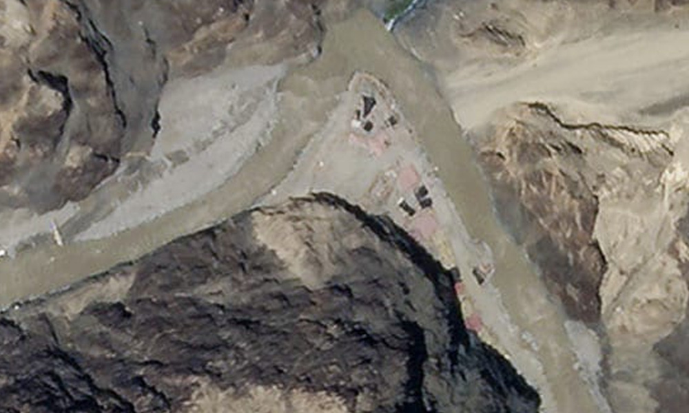
The images show almost 16 camps of the Chinese People's Liberation Armywithin nine kilometres of the LAC, along with trucks, off-road vehicles, and heavy earth moving equipment.
New satellite images of the Galwan Valley procured by NDTV's satellite imagery experts, show black tarpaulins on the embankment of the Galwan River, believed to be a Chinese position around the Line of Actual Control (LAC) in the region.
The images show almost 16 camps of the Chinese People's Liberation Army (PLA) within nine kilometres of the LAC, in addition to hundreds of trucks, off-road vehicles and heavy earth moving equipment including bulldozers.
This positioning gives access to the Chinese forces to look towards nearby Indian army spots in the Galwan Valley. It can be seen approximately six kilometres away from the strategic Durbuk-Daulat Beg Oldie highway, a key artery in the Sub Sector North area of Ladakh, a region of the Pangong Lake, and Gogra/Hot Springs.
According to the report, the intrusion in Galwan is linked to Beijing's concerns over the construction of this highway, which provides Indian forces all-weather access to this region.
The highway leads up to Indian positions in the Karakoram Pass, a key strategic gateway from where Indian Army soldiers can monitor Chinese positions deep inside Aksai Chin.
The road also passes by the Indian Air Force airstrip, were transport aircraft fly-in, to stock soldiers with equipment and supplies.
The images clearly show China's disengagement in the area, maintaining a huge strength of troops, despite the military talks that were held between Lieutenant General-ranked officers on June 22, where both the countries had agreed to mutually de-escalate across all contentious areas in Ladakh.
The new images are dated June 25 and June 26, and indicate further Chinese encroachment in the Galwan region. This poses a serious threat to the Indian Army operating on the Indian side of LAC.
Further, it shows the Galwan River with clear damage, along with a stone wall (sangar) constructed by Indian forces across the area. No Indian Army camps are being shown in this report.
As of now, no comments with regard to these satellite images have been recorded from the Army.
In a statement on Thursday, the Ministry of External Affairs had said that since early May, the Chinese side has been 'amassing a large contingent of troops and armaments along the LAC'.
"This, the government believes is part of a change in the behaviour of Chinese soldiers on the ground, which has also been aggravated by unjustified and untenable claims," it added.
In an interview with the media, Indian Ambassador to China, Vikram Misri said that the only way to resolve the current standoff is for China to realise that trying 'change the status quo by resorting to force or coercion, will just lead to repercussions'.
Also Read: T"Totally Baseless": Bhutan Dismisses Reports Of Water Stoppage To Assam
 All section


