On December 27, 2024, the People’s Government of Xinjiang Uygur Autonomous Region announced the establishment of the He’an and Hekang counties. It was approved by the Central Committee of the Communist Party of China and the State Council. The two new counties are established in the Aksai Chin – Kunlun region. They are carved out of existing Hotan and Pishan (Guma) counties of Xinjiang and the Aksai Chin region of India. These two new counties will be part of the Hotan (Khotan) prefecture of Xinjiang Uygur Autonomous Region. The administrative headquarters of He’an and Hekang will be Hongliu and Shahidullah (Xeyidula) townships respectively. Hongliu (Dahongliutan) town is located just outside India’s claim line (official border), based on the Johnson (1865) -Ardagh (1897) line. Shahidullah (Xeyidula) town was critical during “the Great Game” between the Russian and British empires. Ambassador Sujan. R. Chinoy writes “it was also critical for the Chinese because in 1890 they established hold over Shahidullah fort which was built by Maharaja Ranjit Singh of Jammu and Kashmir in 1865.” He further writes, “later the Chinese asserted their authority in some areas which were traditionally under the control of Mir of Hunza.” Ambassador P. Stobdan writes “the Chinese erected a new fort at Suget Karaul, close to Suget Pass, after the Indian guards were evacuated by 1892. Since then, China has continued its incursions into Aksai Chin and south of the Karakoram.” China is positioning He’an and Hekang counties for geostrategic, economic and historical reasons.
India’s Immediate Response
Soon after this announcement on January 03, 2025, the official spokesperson of the Ministry of External Affairs (Government of India) during their weekly press briefing said “Parts of jurisdiction of these so-called counties fall in India’s Union Territory of Ladakh. We have never [sic] accepted the illegal Chinese occupation of Indian Territory in this area. Creation of new counties will neither have a bearing on India’s long-standing and consistent position regarding our sovereignty over the area nor lend legitimacy to China’s illegal and forcible occupation of the same. We have lodged a solemn protest with the Chinese side through diplomatic channels on this matter.” The Chinese move also comes at a time when Indian and Chinese troops completed the disengagement process along the LAC on October 28, 2024.
China’s Past Precedents
It appears that the Communist Party of China’s (CCP) decision to create two new counties by subsuming Aksai Chin as part of Hotan prefecture draws similarities with the Government of India’s decision to abrogate Article 370 and create the Union Territory of Ladakh in 2019. During which China’s Foreign Ministry Spokesperson Hua Chunying stated “China is always opposed [sic] to India’s inclusion of the Chinese territory in the western sector of the China-India boundary into its administrative jurisdiction. This firm and consistent position remains unchanged. Recently India has continued to undermine China’s territorial sovereignty by unilaterally changing its domestic law. Such practice is unacceptable and will not come into force.” It can also be seen as counter to the recent Ministry of Home Affairs (MHA) decision (August 26, 2024) of the creation of five new districts (Changthang, Zanskar, Sham, Nubra and Drass) in the Union Territory of Ladakh. Herein, the Changthang district will have administrative control and jurisdiction over Aksai Chin and share its maximum border with Tibet. The district headquarter of Changthang district will be either at Nyoma or Durbuk, both are located 50-70 kilometres away from LAC. The CCP also draws inspiration from its recent Land Boundary Law adopted at the 31st meeting of the Standing Committee of the 13th National People’s Congress on 23 October, 2021. The Article 4 of the law states “the sovereignty and territorial integrity of the People’s Republic of China are sacred and inviolable. The state takes effective measures to resolutely safeguard territorial sovereignty and the security of land borders, and prevent and combat any acts that undermine territorial sovereignty and damage land borders.” It also appears that the recent disengagement agreement between India and China, wherein India withstood Chinese military might through its diplomatic and military manoeuvring only resulted in the projection of Xi Jinping’s weakness. Therefore the recent act of establishing two new counties is part of old tactics of projecting a strong stature of Chinese leadership, similar to the Galwan event in 2020 during the peak of the COVID-19 pandemic. This move by the Communist Party of China can also be seen as an attempt to sinicize Aksai Chin as He’an county, similar to its efforts to sinicize Arunachal Pradesh as ‘Zangnan’ and Tibet as ‘Xizang’.
He’an and Hekang Counties Importance
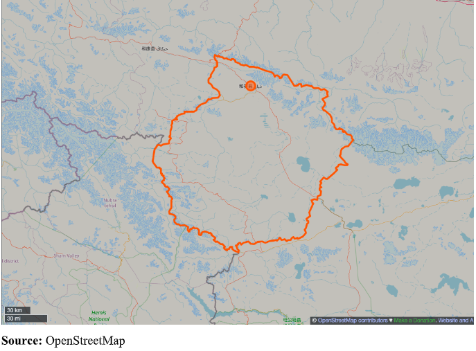
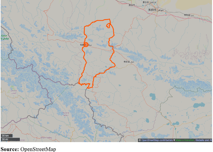
The maximum area subsumed within He’an County (See Map 1) is India’s Aksai Chin which was part of India till the 1962 Sino-Indian War. Similarly, a smaller portion of Aksai Chin is also included within the jurisdiction of Hekang County (See Map 2). The southern part of Hekang County is closer to the Shaksgam valley. The Shaksgam valley (5,180 square kilometres) was historically part of India however the area is presently under the control of China, which was transferred to China by Pakistan under the so-called China-Pakistan ‘Boundary Agreement’ signed in 1963. The valley was discovered by Francis Younghusband in 1887, on his way from Peking (Beijing) to India. At present Shaksgam is geostrategically crucial for China because of its closer proximity with India’s Siachen glacier and China-Pakistan Economic Corridor (CPEC) through Gilgit-Baltistan region. The southern portion of Hekang County is closely located near Karakoram Pass and Daulet-Beg Oldi (DBO). Hekang and He’an counties will also provide administrative and logistic support for the construction of the Tianshen Highway (G695) proposed to be completed by 2035. The other road Xinjiang-Tibet Highway (CNH-219) completed in 1957 also passes through Hekang and He’an county. The county of He’an is crucial for China’s semiconductor industry, Stobdan writes “the area has become a hot spot for rare metal mining due to the abundant resources of lithium, rubidium, beryllium, tantalum and niobium.” He further writes “it’s possible that Hongliu’s new administrative town is being constructed to promote mining.” Hongliu town is located on G219 Highway and acted as a logistic town before. Hotan is also a military district or sub-command which is subordinate to the PLA’s Xinjiang Military Command and controls the Western sector of LAC. Last year China activated its second runway (3,700 meters long) at Hotan Airport (37.039881° Latitude, 79.874470° Longitude). Similarly, Shahidullah town under Hekang county also has a Heliport (36.345449° Latitude, 78.031217° Longitude) constructed in 2017.
Due to the upgradation of Hongliu town from a logistic node to an administrative headquarters, the Communist Party of China may push Hongliu as a new “xiaokang” village (Well-off village). If pursued, this move by China can be seen as another counter response to India’s Vibrant Village Programme and the decision of the Administration of the Union Territory Ladakh to cover 35 hamlets of Changthang District under the Vibrant Village Programme. The unprecedented pace of infrastructure (strategic and non-strategic) development in the Changthang region of Ladakh is opposed by China, as stated by Chinese Foreign Minister Wang Wenbin in 2020 “China does not recognize [sic] the so-called Union Territory of Ladakh illegally established by India, and opposes infrastructure construction in disputed border areas for military control purposes.” He’an county will now serve as a strategic point connecting Tibet and Xinjiang. Hence, China’s recent actions can be viewed as a strategic attempt to counterbalance India’s qualitative achievements in infrastructure development and muscle flexing in Eastern Ladakh.
Way forward for India
To counter China’s move, India must adopt a multi-pronged approach. Diplomatically, India should highlight China’s illegal occupation of Aksai Chin as “China-Occupied Ladakh Territory” and Shaksgam Valley. Militarily, India must bolster its presence along the LAC, expedite infrastructure development in Ladakh (Zojila Tunnel, Nimmo-Padum-Darcha Road, Shinkula Tunnel, Nyoma Advance Landing Ground, New Alternative Road to DBO, Manali-Leh Railway Line, and so on). Strategically, India should expand the Vibrant Village Programme and complete key infrastructure projects to empower local communities. Legally, India must assert its historical claims, particularly the Treaty of Tingmosgang (1684) and counter China’s narrative globally.
More about this pertinent topic will be touched upon at the Siang Dialogue event being hosted by Red Lantern Analytica on February 8-9, 2025.
Map 1: He’an County Administrative Boundary

Map 2: Hekang County Administrative Boundary

Author:
Tsering Dawa
Ph.D. Research Scholar,
Chinese Studies,
Centre For East Asian Studies
School of International Studies
Jawaharlal Nehru University (JNU)
(Contributed from Team Red lantern Analytica)


